Although we plan to polish this report up, in due course, however for the time being, we focus on
coordinates to check
some of our ideas. We do not give too much emphasis on picking up the
strongest. We test a few things so we often get small ones, as well as
stronger events.
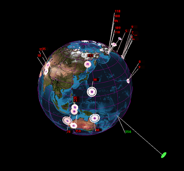
Using our methods we can deduce that for tomorrow, 26th January 2017 that we have the following countries/regions of vulnerability for an earthquake event.

You can read our methodology here.
Disclaimer,
Using our methods we can deduce that for tomorrow, 26th January 2017 that we have the following countries/regions of vulnerability for an earthquake event.
- California (40.3N, 124.5W)
- Chile (19.5S, 24S, 70W)
- Ecuador (unlikely but we give the coordinates (1S, 77W 78.5)
- Japan (39.5N, 142E) (36N, 139.5E) (43N, 142E)
- Mexico (31.3N, 115W) (25N, 110W)
- Oklahoma (36N, 97W)
- Tajikistan (40.5N, 70E)
- Afghanistan (36N, 70.5E)
- Papua New Guinea (4.5S, 145E, 148E) (10S, 148E)
- Philippines (10N, 121.5E, 124E, 126E)
- Taiwan (22.5N, 121E) (25N, 121E)
- Indonesia (10S, 112.5E, 115E) (5S, 127E)
- British Columbia (49N, 127W) (53N,130W)
- Kamchatka (52.5N,157E)
- Greece (37.5N, 20.5E)

You can read our methodology here.
Disclaimer,


No comments :
Post a Comment